| home > tuatapere > information |
|
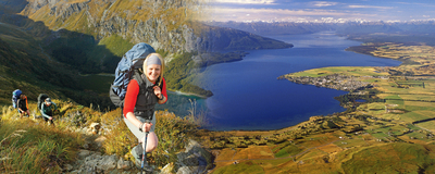
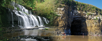
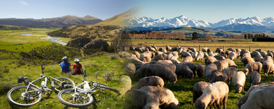
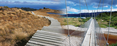
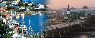
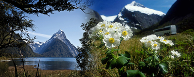
Tuatapere Midway on the Southern Scenic Route on Nature's Edge Western Southland Tuatapere is located on the banks of the majestic Waiau River which is conveniently located on the Southern Scenic Route between Te Anau (98 km) and Invercargill (88 km) and is an ideal location to base yourself for a few days. The centre of a farming community, Tuatapere is often referred to as the "Sausage Capital of New Zealand". It has several art and craft galleries and the Bushman's Museum displays a detailed account of the areas sawmilling history. There are also a number of jet boating, fishing and tramping opportunities available. Some highlights include: RAKATU WETLANDS AND REDCLIFF WILDLIFE RESERVE Home to many waterfowl species, including scaup / papako, grey teal/tete and paradise shelduck/putakitaki, these wetlands provide a network of walking and cycling tracks. TE KOAWA TUROA O TAKITIMU Managed by Kai Tahu, the site has a diversity of mahika kai (producing or procuring food) values, plants, wildlife and fisheries. It represents a resource that can be used to further peoples knowledge of mahika kai values. There are accommodation options and wheelchair-friendly facilities. BORLAND ROAD AND BORLAND LODGE Borland Road is a backcountry 4WD route to the South Arm of Lake Manapouri. Conditions on the narrow road can be treacherous and it is often closed during winter months and occasionally in summer. Contact a DOC office for road conditions. The Borland Lodge Adventure and Education Trust provide a range of accommodation, conference and meeting facilities. BORLAND NATURE WALK (40 min return) An easy short walk opposite Borland Lodge through beech forest, this is one of the best places in Southland to see native mistletoe which flowers in early summer. LAKE MONOWAI Monowai was one of the first New Zealand lakes to be harnessed for hydro-electric power production and is a gateway to the southern part of Fiordland National Park. LAKE HAUROKO Hauroko means "the soughing of the wind". At 462 metres deep, this is New Zealand's deepest lake. The Wairaurahiri River leaves Lake Hauroko and flows through the Waitutu Forest to the South Coast. Accessed from the Lillburn Valley Road, Lake Hauroko is signposted from Clifden. There are varied recreational opportunities in the area and commercial operators to help you explore. The Wairaurahiri River is the steepest river in New Zealand to be navigated by commercial jet-boat operators. The Lake Hauroko Bush Walk is an easy 40 min return loop walk. THE PENINSULA LOOKOUT (30 min return) Walk through mature beech forest to overlook the lower reaches of Lake Monowai. BIG TOTARA WALK (30 min return) Signposted from the road to Lake Hauroko, a pleasant 12km drive takes you to the track entrance Along the track you will see some of the largest totara trees in Southland, over 1,000 years old. McCRACKEN'S REST A viewing platform provides excellent views of Te Waewae Bay and the tiny one million years old Solander Islands to the south - formed by the eroded skeleton of a volcano. According to Maori legend, the Solanders are the broken tooth and crumbs tossed aside by Kewa the whale when it chewed between Stewart Island/Rakiura and the mainland. RARAKAU / BLUECLIFFS BEACH This is the starting point for the Tuatapere Hump Ridge and South Coast tracks. Hectors dolphins / upokohue can sometimes be seen from the beach, as too can southern right whales/tohora. TUATAPERE HUMP RIDGE TRACK (3 day / 2 night hike) Opened in 2001, its reputation as a world-class walking experience was confirmed when it was named as a finalist in the British Guild of Travel Writers' annual tourism awards. This circuit track has all the qualities of a "Great Walk". The first day leads hikers from sealevel up through native forest to the Hump Ridge providing sweeping 360 degree views of the South Coast far below and the peaks of the Southern Alps marching northwards. From the top of Hump Ridge, the track descends almost back to sea-level then traverses along old tram lines and across mighty wooden viaducts to the historic Port Craig. A bush and beach track following Te Waewae Bay completes the circuit on the third day. Visit www.humpridgetrack.co.nz for more information. Bookings are required. CLIFDEN CAVES These limestone caves are one of few cave systems in Southland and are signposted along the Clifden Gorge Road. Ensure you have a good torch with spare batt eries and warm clothing. Ask for advice at the nearest visitor centre. Warning - This cave system is subject to flash flooding. Do NOT enter during or immediately after heavy rain, or if rain events are forecast. To fully explore these caves, caving experience is essential. CLIFDEN SUSPENSION BRIDGE Construction of the suspension bridge started in 1898 when it replaced the punt used by early sheep stations. PORT CRAIG VIADUCTS (7 hr each way) The site of a 1920s timber mill and town, the only remaining historic building is the school which is now DOC accommodation (more comfortable accommodation is provided by the Tuatapere Hump Ridge Track, bookings essential). A self-guided heritage trail takes visitors around relics of the town and mill site. The Percy Burn viaduct (approx 2 hr walk west from Port Craig) is a spectacular site. Information Centres: |